A Route Is More Than the Shortest Line
Compare routes between places by their settlements, crossings, and junctions to choose a journey that fits your purpose, not just the shortest line on a map.
You unfold a county road map to plan a visit, and the pencil line between two villages seems obvious. Then you notice that one road passes through a market town while another reaches the same destination without it. Comparing routes between places means weighing their connections and practical tradeoffs, not merely tracing the shortest line.
Route connections
Start by marking the origin and destination, then trace each candidate route from end to end. Note the settlements it actually passes through, the roads it joins, and any changes in road name. This gives you a clear account of the route’s structure without assuming that one label describes the whole journey.
Map labels can refer to a parish, a group of buildings, or a wider area rather than a compact settlement beside the road. Check the legend and map scale, then consult a more detailed map or local signs if the exact passage matters.
For an everyday trip, the useful comparison is often practical: which route reaches the intended place, uses roads suitable for your mode of travel, and offers a sensible alternative if a turn or crossing is unavailable? A route that passes through a town may provide more options, but could also add stops or decisions.
Crossings and junctions
Rivers, bridges, passes, and road junctions can explain why a route serves particular settlements. A crossing may draw roads toward a town; a junction can link smaller places to a larger center. These are clues to how the county’s connections fit together, rather than proof that a route is currently open or suitable.
Compare the actual points where each candidate joins or leaves a main road. A route with several branches may offer alternatives, while one with fewer turns may be easier to follow. For driving, walking, or cycling, check current access information and signs; a line on a map does not settle conditions on the ground.
Road names provide another clue, but names can change along a route or at a settlement boundary. Trace the mapped line through each junction instead of relying on a single road label.
Purpose and tradeoffs
Choose comparison criteria that match the journey. For a direct visit, consider access, road suitability, and current conditions. For a trip between several settlements, confirm that the route passes through each one rather than merely near it. For a county geography project, record the places and crossings joined by each route.
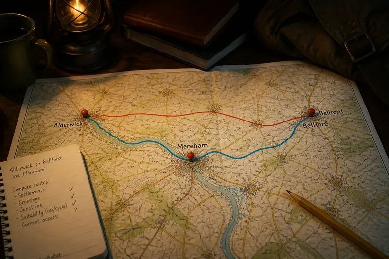
Say you are planning an invented visit from Alderwick to Bellford, with a stop in Mereham. On a county map, the direct road reaches Bellford but does not pass through Mereham; an alternative runs from Alderwick through Mereham and then to Bellford, crossing a mapped river bridge on the way. If visiting Mereham is essential and the bridge route is shown as open and appropriate for your travel mode on current information, the longer route fits the stated purpose. If Mereham is optional and the direct road is suitable, that route avoids an unnecessary stop. The result is a choice based on the visit, not a claim that either route is universally better.
- Settlement access: If the route passes through every required settlement, keep it under consideration; if it only passes nearby, choose another route or check a local connection.
- Road suitability: If the mapped roads suit your travel mode, continue comparing them; if not, select a route marked as appropriate for that mode.
- Crossing status: If current local information confirms a crossing is available, retain that route; if access is unclear or restricted, choose an alternative crossing.
- Junction complexity: If the turns are clear on a detailed map, the route may be straightforward to follow; if a junction is ambiguous, check a larger-scale map or choose a clearer connection.
- Road-name changes: If the route remains traceable despite changing names, follow its mapped course; if the name is your only clue, verify the line and junctions before relying on it.
- Journey purpose: If the route serves the trip’s required stops or geography question, keep it; if it adds places you do not need, compare a more direct alternative.
Route questions?
Is the shortest route always quickest?
No. A short mapped route may use slower roads or involve awkward junctions, and current conditions can alter the choice. Check the route itself rather than treating distance as a travel-time answer.
Why does a road pass through a small settlement?
The settlement may sit at a useful crossing or junction, connecting roads between nearby places. Its position can help explain a route even when a larger town is close by.
How can I identify a useful county connection?
Trace the route’s sequence of settlements and the roads or crossings that link them. A route joining several connected places may matter to county geography even if it is not the most direct line between two endpoints.
Should I rely on a road name?
Use the name as a clue, then follow the mapped route through its junctions. Names can change along the way, so the line and its connections provide the fuller picture.
Keep a clear record
For a final comparison, write each route’s settlements, main junctions, crossing status, and suitability for the journey. That compact record separates what the map shows from what still needs checking. Route connections between places can clarify how a county works, while the intended destination and current access determine which connection is useful now.