A County Map for a Rainy Afternoon
Use a county map reading activity to mark distinct landforms, check the boundary and leave with clear notes about what the map shows—and what it leaves out.
Set a county map beside a pencil and a scrap of paper, and the first useful question is not where the roads go. A county map reading activity can focus instead on how landforms, water, and the administrative edge are represented—and on which details the map makes hard to see.
Choose a clear map
Use a map that shows a county boundary and physical features such as rivers, lakes, elevation, or coastline. A county planning map, a printed atlas, an Ordnance Survey map, or an online mapping service may work, provided its legend identifies the boundary and the map gives enough detail to distinguish the features you want to mark.
Political and physical maps serve different purposes. A political map makes administrative edges and neighboring counties prominent; a physical map gives more attention to relief and water. A road map can be useful for place names, but its route lines may make small landscape details harder to pick out.
Keep the legend and scale in view. The legend explains the symbols; the scale helps you judge how much ground a mark represents. Treat broad color patches cautiously: one shade may stand for several kinds of land that the map does not separate.
Confirm the boundary
Find the county outline in the legend before tracing it. Draw lightly, and follow the mapped line rather than smoothing it into a shape that looks more familiar. A county edge may follow water or higher ground, but it can also cross ordinary countryside.
If the map shows several kinds of boundary, compare its labels with a second map or an official local map. A thick line might mark a county, while a thinner one might show a parish or district. If the distinction remains unclear, record the uncertainty instead of treating the lines as interchangeable.
At a river, lake, or coast, check exactly where the boundary is drawn. It may follow the water, run along one bank, or cross the water. The map’s line—not the apparent shape of the landscape—determines what you can confidently say about the county edge.
Mark landforms, not routes
Choose three physical features that differ in form or setting. Depending on the county, these might be a river valley, a wooded ridge, and a marsh, or a coastline, a low basin, and a chain of lakes. Do not force a dramatic mountain or famous river into the picture; a modest change in elevation can make a useful contrast.
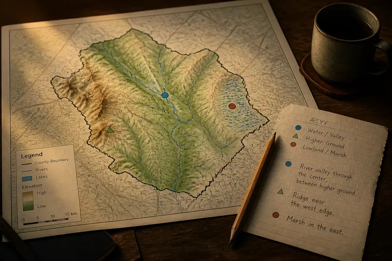
Use small marks and write down each feature’s name if the map supplies one. Add a simple key in the margin, such as a blue dot for water, a green triangle for higher ground, and a circle for lowland. Keep settlements and transport lines separate from the physical features so the map’s categories do not blur together.
For each mark, note its position in relation to the county edge and to the other landforms. This keeps the activity focused on what the map depicts: the county’s physical arrangement, not an explanation of how towns or roads came to be there.
Record map evidence
Look for details that can be described directly: a river crossing the county, a ridge near its western edge, or a marsh occupying part of the east. Avoid turning proximity into cause. A map may show that two features lie close together, but it does not by itself explain why a boundary was drawn or a settlement developed in a particular place.
Say you have a county map whose legend marks a broad river valley, a low ridge, and marshland. First, you confirm the county line in the legend and trace it lightly. Next, you mark the valley, ridge, and marsh with three symbols, then write “valley through the center,” “ridge near the west edge,” and “marsh in the east” beside them. Your resulting note is a supported description of their locations; the tradeoff is that the map cannot tell you why those features or boundaries took their present form.
- Boundary symbol: If the legend identifies the county line, trace that line; if it does not, compare another map before marking it.
- Overlapping boundaries: If county and district lines look similar, check their labels; if they remain indistinguishable, leave the edge untraced and note the ambiguity.
- River course: If the river is named and clearly shown, mark its course; if it is faint or unlabeled, use a more detailed map or leave the name blank.
- Relief shading: If the legend explains the shading, use it to identify higher or lower ground; if not, avoid assigning an elevation meaning to the color.
- Broad color area: If the map distinguishes the land cover you need, note that category; if one color combines several types, describe only the area’s broad position.
- Feature names: If a label clearly belongs to the marked feature, copy it; if its placement is uncertain, record the feature without a name.
- Map detail: If the whole-county view hides a feature, consult a closer view and return to the full map to place it; if the closer view lacks a clear county context, do not claim a precise position.
Questions about county maps?
What can I use without a paper map?
Use a mapping app or online map that displays county boundaries and a terrain or physical layer. Keep the boundary visible as you change layers, and write the three feature names separately so labels do not crowd the view.
How can I tell which line marks the county?
Check the legend, then compare the outline with a map that labels county boundaries clearly. If two lines still seem plausible, note the uncertainty rather than silently choosing one.
What if the county looks physically uniform?
Look for smaller distinctions in water, elevation, or vegetation, such as a river corridor against open ground. If the county-wide view hides them, inspect a closer view and then return to the full map to keep their location in context.
Can settlements count as landforms?
No. Keep towns and villages as separate map features, and describe their physical setting only if it helps clarify the landform. A town beside a river is a settlement next to water, not a landform.
Keep a concise record
Write one note beside each mark: what the feature is, where it sits, and what the map actually shows. “River valley through the center, between higher ground” is more precise than a broad claim about the county’s character.
Check the map’s source and date if a boundary or label appears inconsistent. For an administrative question that depends on current local boundaries, consult the relevant local authority’s map rather than relying on an older general map.
A useful county map reading activity ends with a confirmed outline, three clearly marked physical features, and notes that distinguish visible evidence from unanswered questions. Keep the map and its legend together; without the legend, a tidy symbol can become a small mystery of its own.